Franz Josef Glacier. Roberts point track.
- Jan 3, 2020
- 4 min read
After visiting Hokitika, getting my own greenstone (you can read about it HERE), and seeing some nice blue rivers and peacocks, we continued our journey along the West coast of South Island. We spent the night in a parking lot/camp ground in Franz Josef village. It wasn't the most pleasant place, but at least they had a kitchen and showers included in the price. We drove to the glacier parking lot in the next morning.

Franz Josef Glacier is a ~11 km long temperate maritime glacier. It is one of the steepest and fastest moving glaciers on the planet. Its narrow, steep shape is perfectly formed for ice flow. Most glaciers move at an average speed of around 50 cm to one metre per day, Franz Josef Glacier has been known to move at up to 4 metres per day. Franz Josef Glacier is a highly sensitive so any climate changes can trigger its changes.
Franz Josef Glacier has been in a period of retreat since 2008, losing around 800 metres of length in the past 8 years. In 2012 a hole developed in the ice causing major ice loss to the terminal face. To put this in perspective, Franz Josef Glacier has retreated around three kilometres since the late 1880s.
Instead of just hiking to a glacier face that would take around 1,5 hours, we decided to make a little challenge for us (and maybe we felt a little invincible after Avalanche peak :D ), so we chose to take a long route via Roberts point track. Roberts Point Track was the first track up the Franz Josef Glacier Valley. It's a bit of a hike at 11km round trip, which is about a 5 hour walk.
But if you do not feel that adventurous Franz Josef Glacier walk is still a really good option to walk up to the base of Franz Josef Glacier from the car park. Walk past a waterfall along the wide river stone track, and it is suitable for children. The only downside is that you can't get that close to the glacier face anymore because it's receded too far.
If you decide to be a little more adventurous like we were, pack some snacks, water and a rain coat and be ready to take in those views.
Within fifteen minutes we walked past Peters pools. This is where the glacier used to be.


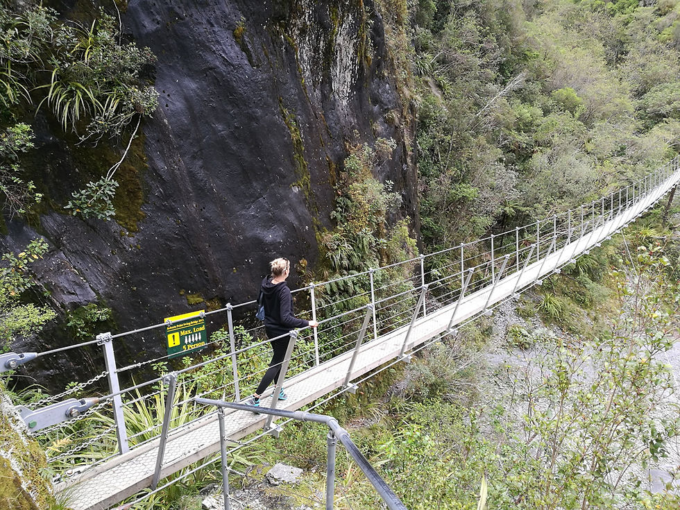
After couple of minutes we were standing at the first of six swing bridges to cross for the day.

I didn't know that when we started the walk. As I really don't like heights, this was a big challange for me. I somehow manage my fear to get across the river, but when I realized that there are more and more swing bridges to cross, I wasn't happy. The thought of crossing them again on our way back scared me even more.


The track ir pretty well formed but you have to cross some little streams on the way. If you are careful enough you will not end up with wet feet, unless there has been some heavy rain in the previous days. We were pretty lucky because it didn't rain at all that day.


You also should be careful and not walk off the trail. This is not a loop trail, so you will have to come back the same way. There are signs warning people. Because some thinks that they can make up their own rules and cross the river just to make a shortcut. For some it has cost a life.

After almost two hours or so we reached the Hendes Hut. It's not really a place where to spend the night, but it is definitely a good spot where to hide from the rain. You can definitely reach it in an hour, but we didn't rush. Also in some places the track was slippery, so better safe than sorry.


After couple of minutes we reached the Gallery steps. It was quite scary to climb down, as they are attachet to a huge rock wall from the outside. But it is pretty cool at the same time.


After that we had to walk accross plain rocks, and it wasn't easy as you can slip any minute. But we did it. Soon after that we reached Roberts Point Track. There is wooden deck with comfortable seating and a table for a picnic. We were the only ones there so I am guessing that not a lot of people choose this track.


You can also see the glacier very good from here. Unfortunately I was a little disapointed. You can't really see the river below you because of the bushes. Also because the glacier has receded a lot, it is still pretty far from the lookout. I read that in 2010, glacier was right below the lookout, but now it isn't. So if you want to strecth your legs and do something active, it is a nice hike to do, but don't have to much of an expectations. The view isn't as stunning. We did this hike in around 6 hours in total, with all the rest stops and picture taking. Maybe they will elongate the track one day so people can get closer to the glacier, but as for now I think 2,5 to 3 hours to the mediocre view is a bit much. It's still a nice hike, especially if you like swing bridges, waterfalls and forests covered with moss.


Comments